

We spent a lovely few days in L.A. with my brother’s girlfriend’s parents (thanks again Elsie and Henry!) and went on a big road trip to see some of America’s amazing National Parks that we didn’t have a chance to visit while cycling (since we rode along the West Coast of the US).
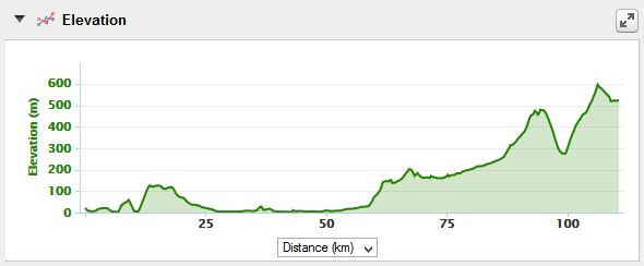
After a few weeks off the bike, it was a tough 3 days, especially Day 3, where we climbed over 1200m up a steep road to the Mexican border at Tecate.
We had originally planned to cross the border at Tijuana, but we decided to cross at Tecate instead and take Highway 3 through the Ruta del Vino for some wine tasting! We had read another cyclist’s blog and realized that there would be a fair bit of climbing to get to Tecate from San Diego and that it was a slightly longer route, but we thought it would be nicer.
In hindsight, although the road up to Tecate was steep and a little hairy at times, the border crossing was easy and the town of Tecate was small and easy to navigate through and Highway 3 (which took us all the way to Ensenada) was brilliant, with wide shoulders, in all but a few sections. Having heard some stories about chaotic and time consuming border crossings at Tijuana, I would definitely recommend Tecate as a great entry point into Mexico, especially if you like your wine! ![]()
Thursday 4th December: LA to Huntington Beach
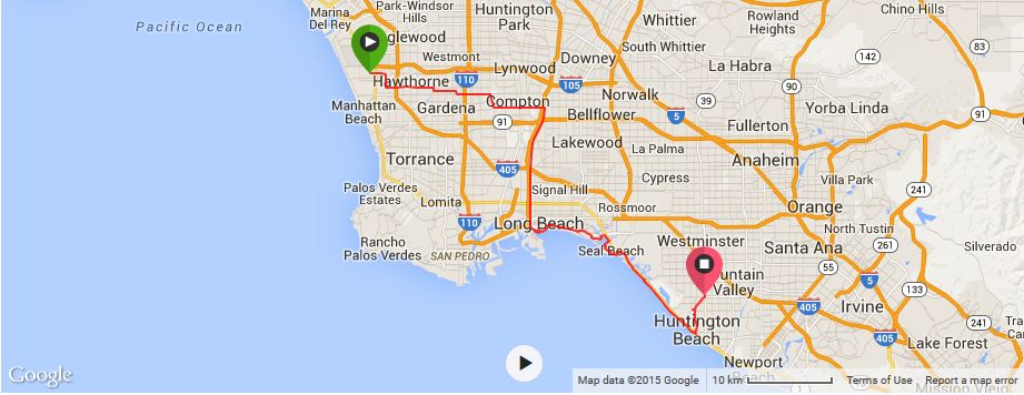
We started late, around lunchtime, so only managed 77kms this day, but we made it out of LA to Huntington Beach, so that was an achievement in itself!
We had been staying in El Segundo and thought we might be able to cycle directly from El Segundo through some of the LA suburbs, rather than backtrack to the coast and follow the Adventure Cycling Association route. If we had to do it again, I would probably cycle back to the coast, rather than follow the route that Google Maps directed us to, through Compton and then along the LA River Bike Path. Nevertheless, it was an adventure and we saw parts of LA that we would not otherwise have seen! ![]()
LA has a fabulous cycle path through the beach, but the route we took, prior to reaching the LA River Bike Path, was not really geared for cycling. There were minimal, if any, bike paths. However, the motorists were generally friendly and gave us room on the road.
After a while, we got the sense that we were cycling through a less savoury part of LA. We passed bullet casings on the road, a clump of hair (!) and David saw men carrying guns. We weren’t exactly scared, but we didn’t want to stick around either. We had been wearing our fluro yellow cycling vests, so we would be visible to the LA motorists. But we took them off, not wanting to stick out too much.
At one point we stopped at a 99 cent store to buy some water. I stood outside to watch the bikes, while David went into the store to get the drinks. There was soon a little crowd around our bikes and I did not feel overly comfortable about the attention that we were receiving, although it was generally positive.
We quickly moved on and eventually reached the LA River Bike Path. If you have seen Terminator II, you would remember the Los Angeles River which the bike path runs alongside (it is where John rides his motor bike after encountering the terminators in the shopping mall)! The bike path was better, because we were off the road and away from the traffic, but at the same time, it seemed quite remote and not well frequented. There were homeless people living under the bridges and we passed these points as quickly as we could.
Following the LA River Bike Path, we eventually reached Long Beach, which was a welcome sight. We cycled past the Palm Beach Park and then the Shoreline Aquatic Park, where we were stopped by a retired cycle tourer from Long Beach, who was keen to hear about our tour. He informed us that the beach bike path was closed for construction, and offered to show us an alternate “bike friendly” route. We happily agreed and cycled with him for about 10kms through some beautiful beachside suburbs, until we reconnected with the beachside bike path at a later point.
We then continued on by ourselves, either on the Pacific Highway or on the lovely beachside bike paths until we reached the Huntington Beach Bike Trail, which runs right beside the beach. What a beautiful wide bike path! We followed this bikeway all the way to Huntington Beach and then called it a day. There were no campgrounds in Huntington Beach, so we opted for a cheap hotel about 5kms inland from the beach and getting ready for Mexico, we had burritos for dinner. ![]()
KMs travelled: 72km
Friday 5th December: Huntington Beach to Cardiff by the Sea at San Elijo State Beach

After our rather short day the day before, we were keen to make up some distance, as we wanted to be in Mexico for my birthday on the 7th December. We cycled 115kms and I, unfortunately, was not feeling well for most of it. ![]()
From our hotel, we back tracked to the Huntington Beach Bike Path, which we followed until it joined the Pacific Coast Highway. We had a little trouble following the directions for the cycle paths on this day. At Newport Beach we left the Highway thinking that the cycle path separated from the Highway at this point. Thankfully a friendly lady directed us back to the Highway, which we followed until Laguna Beach. ![]()
Although the Highway had a bike path, the road was very congested and the cars seemed a little less patient with cyclists than in other parts of California. We were on the lookout for a bike shop (as David needed to buy some more butt cream :)). Luckily we found ‘Laguna Beach Cyclery’ in Laguna Beach. It was a nice little bike shop, with a good range (including the Assos butt cream that we needed!), although it was a tad pricey. Right next door was The Stand, a cool little vegan café. There were a number of cyclists out the front of The Stand having coffee, so we knew we must be in the right place and decided that it was surely time for second breakfast! While I had a coffee, we chatted with some of the local cyclists who warned us against cycling any further along the highway, as a lot of cyclists had been killed along the next stretch. They gave us directions to follow and we wound our way through the back street for the next few kilometers, before eventually heading back to the highway.
We were following the Adventure Cycling Association maps, so around San Clemete we left the highway and started following the bike path through the suburbs. Fortunately, at this point we met two lovely local cyclists, Karen and Courtney, who guided us through the maze of back streets. David had a wonderful time chatting with them (I was feeling nauseous, so I rode behind the others).
Karen is a very inspiring cyclist. She had set herself the goal of cycling 12,000 miles in 2014, and was well on track to achieving it. Karen and Courtney kindly offered for us to stay at their place, but we needed to keep moving if we were going to cross the border into Mexico the next day. Courtney gave us some invaluable directions, especially regarding the turn off to Camp Pendleton, as the bike path is not particularly well sign posted at times. We left Karen and Courtney and cycled along the Old Pacific Highway, which was perfect for cycling – good surface, wide road and no traffic.
We followed the Old Pacific Trail under the new highway and when we came to a T-junction we turned left (thanks to Courtney’s directions) and found ourselves at a naval checkpoint, at the entrance to Camp Pendleton. I wasn’t sure if we had taken the right road, but the armed naval officer assured us that the bike path went through the naval base. We were asked to show our passports, which we did, and were then waved through. I felt a little strange to be cycling through a naval base, with lots of navy personnel around, but we didn’t have any problems and were soon cycling into Oceanside.
We planned to stay at the San Elijo State Park, which has a hiker/biker campsite, near Cardiff-by-the-Sea. We arrived just before dark and were pleased to see that we were the first cycle tourers to arrive. The campsite was $20 for 2 people ($10 per person). We were required to show ID and unlike the other RV campers, we needed to vacate the campsite by 9am the next morning. Although, we didn’t have a problem with this in theory, as we wanted to get an early start the next day, we wondered why we were being treated differently to other campers. I assume it is due to the problems that the California State Parks Department has had with homeless people using the hiker/biker campsites.
Unlike in Oregon where the hiker/biker campsites were generally located in prime locations in the state parks, the hiker/biker campsite at San Elijo State Park was located right next to the noisy highway. Shortly after we arrived another friendly couple of cycle tourers from Canada arrived. They weren’t impressed with the location of the campsite and wondered if we would be interested in sharing the cost of a regular campsite, closer to the beach. We readily agreed, but were informed at the rangers office that the park was booked out. ![]()
I was feeling pretty unwell at this point. David went to the local supermarket and bought some pastries for our dinner and brekkie the next morning. I made the BIG mistake of eating a pastry while still in my sleeping bag in the tent. I woke up at midnight with ants crawling all over me! Waking up to find that ants are actually crawling all over you, and that it is not a dream, is really not nice. Needless to say, I did not sleep well that night …. I will never eat in the tent again. Never.
KMs travelled: 115km
Saturday 6th December: Cardiff by the Sea to Tecate, Baja California
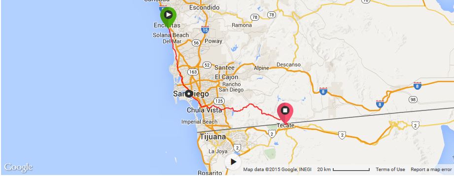
Thankfully, I was feeling much better the next morning, notwithstanding the bad night in the tent due to the ants. We were up and on the road by 7am, before the other cycle tourers had surfaced. I wanted to get an early start, because I knew the road up to Tecate would be steep and I wanted to cross the border while it was still light.
It was Saturday morning, so the local cyclists were out in force, which is always fun. There were some steepish hills around the Torrey Pines State Nature Reserve, but it was all very manageable. We were cheered on by some of the local cyclists on their road bikes and some even slowed down to cycle with us and ask about our tour, which was really nice. We had heard that the coastal area around La Jolla is particularly beautiful, but we decided to bypass it and cycle directly to San Diego, as we weren’t sure how difficult the road would be up to Tecate. Following the directions of some local cyclists, we cycled through the University of California San Diego and made our way to a good bike path, which took us to the outskirts of San Diego. We then cycled through De Anza Cove Park, Mission Bay Park, Playa Pacifica Park and Tecolete Shores North Park, where we had to dodge joggers, pedestrians and dogs. I was happy when the bike path merged again with the Pacific Highway, so we could make better progress.
We reached San Diego early in the morning. It is a lovely, friendly city, which was easy to bike around. We were cheered by a number of the locals when we entered the city centre, which was lovely. We stopped to take a few photos of the harbor and a big aircraft carrier, the Midway, and met a rather eccentric (toothless) local who said he had cycled through Mexico a number of years ago. We listened to a few of his stories, but had to keep moving, as we still had a lot of ground to cover that day.
As we cycled out of San Diego, we met some other local road cyclists. We rode with them for several kilometers, until they had to turn around. While still in the San Diego city limits we saw an ‘In and Out Burger’. We still hadn’t tried one and as it was our last opportunity, we stopped in for an early lunch. Although it was still early, around 11.30am, it was packed. As soon as we tried the burgers we knew why. The burgers were delicious!
Cycling out of San Diego we took the Bonita Road and then turned onto the Otay Lakes Road. From here the road started to climb, although it was pretty gentle at first. We saw some other cyclists on the Otay Lakes Road, so it is clearly a popular route for local recreational cyclists as well. Otay Lakes Road turned left at one point and the scenery became less urban and more remote after this point and the number of cyclists thinned to one or two only.
Eventually, we came across beautiful Otay Lake. I stopped to take some pictures, while David rode on ahead. I caught up to him shortly after at Skydive San Diego. We took a break and watched the sky divers floating down to earth.
By this time I was starting to feel quite tired … but we pushed on. We passed the Pio Pico RV Camp (which has tent sites), which looked fantastic. It is located 30kms from the border and would make a great halfway point if you don’t fancy cycling all the way from San Diego to Tecate in one go. We, however, had already booked a hotel in the Guadalupe Valley for the 7th December for my birthday, so we kept cycling. Up.
About 27kms from the border, we turned right from Otay Lakes Road onto Campo Road. Interestingly (and thankfully), no RVs or big trucks were allowed on Campo Road. We were also surprised by the number of border control vehicles. Every 3rd car seemed to be a border control vehicle. Up until this point the incline had been very manageable, but it became steadily more challenging. Apart from my fitness, the main issue was the very limited shoulder, and at times, no shoulder at all, and the cars and trucks, which zoomed past us without any apparent regard for the speed limit. The cars and trucks were heavily loaded with furniture, which they were obviously taking across the border to Mexico. It made for a rather hairy ride for the last 20-25kms to the border.
In addition to the traffic and steep road, we had run out of water. Thankfully, 20kms from the border, we came across the tiny town of Dulzura. We had a couple of parcels to send and Dulzura had the tiniest post office that we had ever seen! We asked where we could fill up our water and were told that the water around Dulzura and anywhere else from there until the Mexican border was not safe to drink, but the kind post office lady refilled our bottles from her own water bottle. I love the kindness of strangers!
I had to stop a couple of times on the last 20kms due to cramp in my feet, but eventually we made it to the top and enjoyed a brief downhill into Tecate.
We had been reading up on the specifics of the Mexican border crossing and we were under the impression that it would be complicated and that we wouldn’t be able to pay for the visa at the border itself. But, the border crossing at the Tecate office was easy. Initially, we joined the queue of cars, but were waved towards the pedestrian office (on the right). We left our bikes out the front, under the “apparently” watchful eye of a border official. The border official that we met inside spoke some broken English, which was great, as my Spanish was rubbish at this time. We filled out the necessary paperwork, paid the requisite fee (306 pesos each, which they rounded up to US$25), and left with a 6 month visa. We had to pass through a security check before we were allowed into Mexico. However, the search was half-hearted and not thorough at all. We were only asked to remove our front panniers. They were put through the scanner and we were then waved through. Simple.
David had bought a “Mexican cycling jersey” to wear in Mexico, which displayed the Mexican flag and the official Mexican coat of arms.The border officials were reasonably friendly and told us that although wearing a jersey with the Mexican flag was ok, wearing a top with the Mexican coat of arms was illegal in Mexico. They said we would get fined by the police if David was caught wearing it in Mexico, but that they were happy to turn a blind eye. We thanked them for their advice and put our jackets on to cover up the coat of arms.
We crossed into Mexico around 4.30pm, which was perfect, as we were able to find a cheap hotel before it got dark. The street was full of pot holes, but the cars were respectful and everyone was very friendly. We found a cheap (but slightly dodgy) room for 220 pesos (US$15). After having a quick shower, we went out in search of an ATM and food. We found an ATM in the local chemist and then stumbled across a brilliant little taqueria. Thankfully, the staff spoke a few words of English, so we were able to communicate our order. We marveled at the skill and speed with which the taco chef constructed our tacos … his arms were literally spinning as he put the tacos together! We added salsa, lime juice, chilli sauce and coriander and were soon in taco heaven. ![]() I am not sure whether it was because I was so exhausted from the climb up to the border, but those tacos are still the best tacos that I have ever tasted. We had 7 each!!
I am not sure whether it was because I was so exhausted from the climb up to the border, but those tacos are still the best tacos that I have ever tasted. We had 7 each!!
While we were devouring our tacos, we watched the local “Tecate Christmas pageant”. It was unlike any Christmas pageant that David or I had ever witnessed. It had the typical Christmas floats, but with music blearing and everyone dancing, it was like a techno concert! We loved every minute of it. I remember going back to our room feeling extremely happy with our first night in Mexico, and less apprehensive than when we originally crossed the border! ![]()
KMs travelled: 111km

San Diego Harbour

San Diego Harbour

San Diego Harbour

San Diego Harbour

View of Lower Otay Lake from Otay Lakes Road

View of Lower Otay Lake from Otay Lakes Road

View of Lower Otay Lake from Otay Lakes Road
Lower Otay Lake

Lower Otay Lake

Sky divers on the road to Tecate

Sky divers on the road to Tecate

Sky divers on the road to Tecate

The road to Tecate

The road to Tecate

The road to Tecate

The road to Tecate

Tecate Mexican Border Crossing

David at the Tecate Mexican Border Crossing


Recent Comments