

We had a wonderful break in San Francisco catching up with two of David’s Tour d’Afrique buddies, Chris and Mateo, and another friend Shangrila, who we met on the African Safari that we did last year. We stayed at Chris’ house in The Mission, which was a fabulous base from which to explore San Francisco (thanks again Chris!).
We explored the city on foot (I particularly loved Golden Gate Park) and went on an awesome bike ride with Mateo over the Golden Gate Bridge. We visited the different villages, had some amazing Japanese, Spanish and Italian food, visited Vesuvio (an iconic SF bar) and saw the “Day of the Dead” procession through The Mission. We also went on a great little side trip to the beautiful Yosemite National Park.
Unfortunately, it wasn’t all fun in SF, as we both got sick (nothing serious, just the flu). But we didn’t mind lingering a bit longer in such a great city. But after two weeks, it was time to get back on the road.
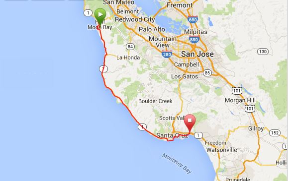
Friday 7th November: San Francisco to Half Moon Bay

Mateo had kindly offered to be our tour guide and help us find our way out of San Francisco, which was awesome, as big cities can be hard to navigate (thanks Mateo!). I was still sick and feeling a bit nauseous, but I started to feel better as we pedaled out of the city (clearly bikes have healing powers!). Mateo accompanied us as far as Daly City, which was the most confusing part, where he got a flat tire (apparently this was quite reminiscent of TDA :)). So we said our goodbyes and headed off towards Half Moon Bay on our own.
The weather had been fabulous while we were in SF, but it started to turn as we left and we rode away from Daly City in fog.
Although we were using the Adventure Cycling Association’s maps for the Pacific Coast Route, we also often use Google Maps’ bike function to help with some of the trickier sections and to show the daily elevation. Google Maps recommended a different route to Half Moon Bay, which followed a number of coastal bike paths and then took the Old Pedro Mountain Trail around Pacifica. We decided to try it.
We cannot recommend the Old Pedro Mountain Trail highly enough. It was one of the best trails that we have ridden so far on this trip. If you are cycling this way, jump onto Google Maps and get up there! It’s a bit tricky to find, we had to cycle some back roads to get there, including along a private road, but eventually we came to a gate which marked the beginning of the Old Pedro Mountain Trail. The trail used to be a road crossing over Pedro Mountain, but is now a trail for hikers, horses, mountain bikes AND cycle tourers! The path traverses the Pedro Mountain and provides a great cardio workout! The path alternates between dirt, sand and asphalt, with remnants of the old road still visible. I can imagine that there are great views over the ocean on a clear day, but when we rode it the mountain was enveloped in fog, which made for an interesting ride!
The Old Pedro Mountain Trail ended in Montara and from there we wound our way through the back streets of Moss Beach until we came across the Half Moon Bay Brewery. What a find! ![]() It was happy hour when we arrived, so we decided to take advantage of the happy hour specials and had an early dinner.
It was happy hour when we arrived, so we decided to take advantage of the happy hour specials and had an early dinner.
From the Brewery, it should have been a short 7km ride to our hiker/biker campsite at the Half Moon Bay State Beach along the coastal bike path. However, a bridge along the coastal bike path was closed, so we had to backtrack and take the main highway. When we finally reached the campground, we saw that it was closed for renovations! We went in anyway, thinking that no-one would mind if two tired cycle tourers spent the night, but a park ranger spotted us and told us we had to leave. ![]()
So we got back on the bikes and pedaled another 5kms or so to a private campground located next to a tacky looking “English style” pub. We forked out $45 for the a small rocky campsite next to the road. Although the campground had great facilities, $45 for camping is highway robbery in my opinion! Unfortunately for the other campers, I was still pretty sick and spent half the night coughing.
KMs travelled: 56.3km

Old Pedro Mountain Trail

Jo cycling the Old Pedro Mountain Trail

Old Pedro Mountain Trail

David cycling the Old Pedro Mountain Trail

David cycling the Old Pedro Mountain Trail

David cycling the Old Pedro Mountain Trail

Old Pedro Mountain Trail

Views from the Old Pedro Mountain Trail

David cycling the Old Pedro Mountain Trail

David cycling the Old Pedro Mountain Trail

Half Moon Bay, California

We made it for happy hour at the Half Moon Bay Brewery

Half Moon Bay Brewery

Half Moon Bay Brewery

Views of Half Moon Bay

Half Moon Bay, California

Half Moon Bay Brewery

Our dinner at Half Moon Bay Brewery – yum!

Our dinner at Half Moon Bay Brewery – yum!
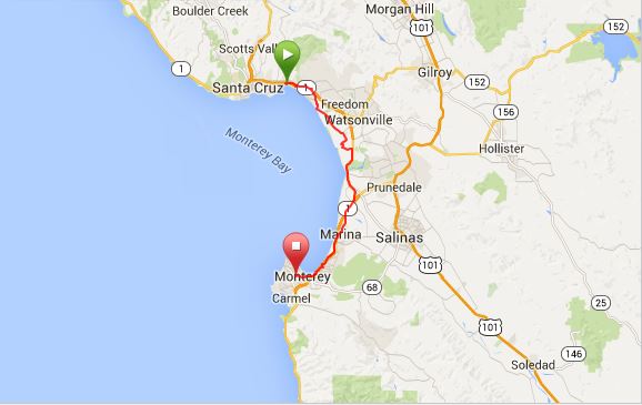
Sat 8th November: Half Moon Bay to New Brighton Beach State Park (Santa Cruz)
We backtracked a bit from the campground to the local supermarket to grab some brekkie and cough medicine and then we started off towards Santa Cruz. There appeared to be two bike paths – one next to the highway and a coastal bike path next to the ocean. Having enjoyed the Old Pedro Mountain Trail the day before, we chose the coastal bike path. We followed it for about 5-10kms, but the path was pretty rough and we weren’t making very good time, so we decided to go back to the highway.
Being Saturday morning, the highway was full of road cyclists out for their morning ride. We met a number of lovely cyclists, all keen to know where we had cycled from and how far we were going.
The coastline between Half Moon Bay and Santa Cruz was absolutely stunning and the weather was perfect. I stopped frequently to take in the views and snap some photos.
Around lunchtime we saw a great sign – “Brewery Ahead” – announcing that Highway 1 Brewery was coming up. Awesome! Time for lunch and some beer tasting! I had the “Rock Queen”, while David had a “French Mexican War”, which had chili in it – not bad! ![]()
After lunch we continued cycling towards Santa Cruz. We passed many beautiful beaches and a few towns. In the afternoon, I came across a jam factory, which was offering jam tastings and a 10% discount to cycle tourers! Fantastic – we needed more jam. Never having tried a “tayberry” before (a cross between a raspberry and a blackberry) I chose some “Tayberry Jam”. Yum!
Just before Santa Cruz we left the highway and followed a coastal bike path into Santa Cruz. Wow! Santa Cruz is stunning! The houses and restaurants along the beach were gorgeous and the amusement park was packed. We stopped to watch some surfers, but then had to get back on the road as we wanted to get to the campground before dark. We followed Google Maps’ helpful directions to get to the campground and wound our way through a series of backstreets to get to the campground. We cycled through Margaritaville, Capitola, which looked like a fun place to dine and hang out, but we pushed on to the campground.
We arrived at New Brighton Beach State Park just before sunset. While David set up our tent, I took photos of the brilliant sunset. ![]() We had pasta for dinner and went to bed early in the hope of getting an early start on Sunday.
We had pasta for dinner and went to bed early in the hope of getting an early start on Sunday.
KMs travelled: 98.66km

Views from the rugged coast bike way, near Half Moon Bay

Views from the rugged coast bike way, near Half Moon Bay

Views from the rugged coast bike way, near Half Moon Bay

The stunning Californian Coast on our way to Santa Cruz

Yeah … Hwy 1 Brewery Ahead!

The stunning Californian Coast on our way to Santa Cruz

Mandatory lunch stop at Hwy 1 Brewery!

Hwy 1 Brewery

The Beer Menu …

The stunning Californian Coast on our way to Santa Cruz

The stunning Californian Coast on our way to Santa Cruz

Gorgeous views on the way to Santa Cruz

Gorgeous views on the way to Santa Cruz

Cycle tourers received 10% discount at the Jam Factory!

Jam tasting on the way to Santa Cruz!

Jam tasting on the way to Santa Cruz!

Surfers at Santa Cruz

Sunset over Santa Cruz from New Brighton Beach State Park

Sunset over Santa Cruz from New Brighton Beach State Park
Sunday 9th November: Santa Cruz to Veterans Memorial Park, Monterey
Scenery wise, cycling from Santa Cruz to Monterey was not a huge highlight. We passed a lovely little Harbour at Moss Landing and some interesting street art, but for the most part the scenery was agricultural – fields of strawberries, cauliflower and brussel sprouts! But the scenery improved with coastal views as we got closer to Monterey.
The highlight today was the people we met along the way. Being a Sunday, the road cyclists were out in force again and they were so friendly to us and helped us with directions on more than one occasion. At one point we accidentally cycled onto the freeway where bikes aren’t allowed. A cyclist saw us and stood in the middle of an overpass gesturing wildly for us to exit the freeway. He then met up with us and pointed us in the right direction.
As we were arriving into Monterey we met another couple of cyclists – Betsy and her husband. Betsy is amazing and has cycled all over the world! From our brief encounter there didn’t appear to be many countries left that she hasn’t cycled through. Betsy knew all about the Tour d’Afrique that David won earlier in the year and was full of enthusiasm for our trip. She really was just the loveliest person to talk to. We spent a good 45min chatting with her and her husband before we had to say good-bye.
We planned to stay at the Veterans Memorial Park in Monterey and had been warned by Mateo that the climb up to the park was steep and that we should get whatever we needed for dinner before we headed to the campground, as we wouldn’t want to cycle it twice. So we headed to Trader Joes (our favourite store) to stock up and then tackled the hill to the campground. Mateo was not wrong. The road to the campground is the steepest hill that we have encountered so far on our trip. I literally had to lean forward to prevent the bike from toppling over backwards!
We booked ourselves into the hiker/biker campsite for the night, noting that a mountain lion had been spotted in the campground recently! Awesome. Veterans Memorial Park turned out to be one of my least favourite campsites, although we did have a good night there. Unlike the other hiker/biker campsites that we had stayed at, there appeared to be a permanent settlement of homeless people living in the hiker/biker campsite. They were friendly enough and kept to themselves while we were making dinner with the other cyclists, but the vibe was different to the other hiker/biker campsites that we stayed in.
We arrived early-ish in camp and I did our laundry while charging our electronics in the bathroom. Other cyclists have had their electronics stolen while leaving them to charge, so we always keep an eye on them. While I was doing the washing, David set up a washing line and did some bike maintenance.
While cooking dinner we met Paul (a cyclist from Las Vegas who is cycling around California for the Winter) and a mountain bike trail builder from San Diego who was on his way home (I can’t remember his name anymore, I’ll just call him the “trail builder”!). We became a core group of 4, who camped together through the Big Sur area. We drank wine and chatted until quite late and then turned in for the night.
We were keen to make an early start the next morning, as was the trail builder, so we agreed to start riding together at 8am. Paul wanted to sleep in a bit, so he said he would meet up with us later in the day.
At midnight, a homeless person arrived and started setting up his tent right next to ours. He turned on his radio and listened to church sermons until 2am! Unbelievable. After this night, my love of the hiker/biker campsite system started to wane and we preferred to stay in cheap motels when we were in bigger cities that were likely to have significant numbers of homeless people.
KMs travelled: 67.64

Views on the way to Monterey

We passed fields of strawberries and other produce on the way to Monterey

We passed fields of strawberries and other produce on the way to Monterey

Interesting street art on the way to Monterey

Interesting street art on the way to Monterey

The harbour at Moss Landing

The harbour at Moss Landing

Monterey Beach

Monterey Beach
Mon 10th November: Monterey to Pfeiffer Big Sur State Park, Big Sur
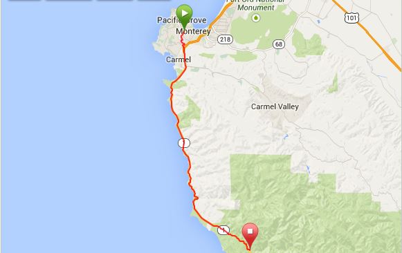
It was chilly when we woke up and the tent, as well as our laundry, was all wet. Great. We quickly packed up and were on the road at 8am with the trail builder. Thankfully, we didn’t need to go back the way we had come the day before. At the north end of the campground we took Via Del Rey, then San Bernabe Drive and then Soledad Drive which led us back to Highway 1. We passed a supermarket in Carmel and the trail builder left to stock up on food for the Big Sur section, where we had been told supplies would be limited.
We kept cycling along Highway 1 until we came to a beach, where we saw two cycle tourers waving at us. We stopped to have a chat. They were from Germany and were cycling from Anchorage to Brazil. They had wild camped the night before and were enjoying their breakfast on the beach when we arrived. Having also met Betsy the day before, they were on the lookout for us. We crisscrossed paths with them all day and they camped with us that night in Big Sur.
Shortly after meeting the Germans we passed a coffee shop. I happily went in for a much needed caffeine boost, having been kept awake for half the night. Then we hit Big Sur! ![]()
The weather really wasn’t perfect for riding Big Sur, but at least it wasn’t too foggy. David rode on ahead at times, while I rode with the German couple, stopping frequently to take in the views and snapping lots of photos. We passed hidden coves, beautiful beaches, the impressive Bixby Bridge, as well as the Point Sur Lighthouse.
Just north of the town of Big Sur, we met another cycle tourer from Germany who was on his way to San Francisco. He had bought a bike in Las Vegas for $150 and had been touring around the US National Parks. David stayed back to chat with him, while I went on ahead to find a campsite and try to dry our wet clothes.
When I finally made it to the town of Big Sur, I was surprised by the numerous accommodation options (including a number of campgrounds), restaurants and grocery stores. No doubt they were pricey, given the remoteness of Big Sur, but we had not been expecting to find much in Big Sur. Our campground also had a Lodge, which was well stocked with beer, food and other camping essentials.
We stayed at the Pfeiffer Big Sur State Park. It was a beautiful campsite in a clearing of redwoods. Unlike previous hiker/biker campsites, we were asked to show our ID and to agree in writing to certain campsite rules. The ranger told us that the ID checks and rule book were required due to vagabonds abusing the hiker/biker campsites. Hmmmm……
The rest of the gang showed up soon after: Paul, the trail builder and the two Germans. David bought some beers at the Lodge and we cooked (Quinoa, tomato and tuna – yum!) and ate together before turning in to get some sleep.
Again, around midnight, a homeless person set up camp next to our tent. Fortunately, he or she was much quieter than the person the night before and they left around 6am before we emerged from our tent.
KMs travelled: 51.84kms

On our way to Big Sur

Gorgeous coastal views, Big Sur

Stunning coastline, Big Sur

Stunning coastline, Big Sur

Big Sur, California

Big Sur, California

Big Sur, California

Rugged coastline, Big Sur

Rugged coastline, Big Sur

More gorgeous views, Big Sur

More gorgeous views, Big Sur

Bixby Bridge, Big Sur

Beautiful beaches, Big Sur

Bixby Bridge, Big Sur

Rugged coastline, Big Sur

Stunning lookout, Big Sur

David at one of the lookouts in Big Sur

Big Sur, California

We camped at Pfeiffer Big Sur State Park

Our campsite at Pfeiffer Big Sur State Park

Redwoods at our campsite at Pfeiffer Big Sur State Park
Tues 11th November: Big Sur to San Simeon State Park
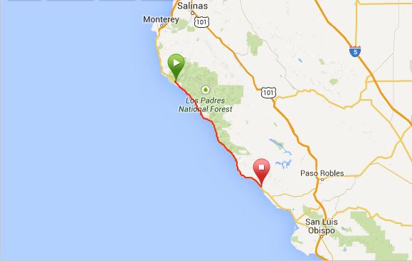
We were up early and on the road before 8am, but not early enough to beat the Germans! They were up and out before 7am – quite impressive ![]()
This was one of our biggest days of climbing – 1496m of climbing. From the town of Big Sur the road climbs sharply, we puffed our way to the top working off our breakfast. We then enjoyed a leisurely coastal downhill, before the road started to climb again. This pattern repeated itself all morning. The scenery was stunning; more beautiful coastal lookouts, stunning beaches (my favourite was lined with palm trees) and the occasional town. We stopped for “second breakfast” on a little turnout overlooking the rugged coastline. Brekkie with a view – doesn’t get much better!
By this time, the trail builder and Paul had caught up with us and together, we caught up with the two Germans, so we became a colourful band of six cycle tourers making our way across Big Sur! It was fun cycling in a group, but the roads were quite narrow, with limited shoulders, so it was difficult for the cars to pass us. When we reached Gorda, we all stopped in for lunch. Unfortunately, the restaurant and grocery store were super expensive, so we didn’t buy anything and just ate our cliff bars.
After lunch the crew broke up a bit, which was probably for the best since there were two massive climbs ahead. Paul started first and we followed soon afterwards. Paul’s bike didn’t have the best gearing, so we quickly caught him on the switchbacks. By the time we got to the top, I was hungry again and low on energy. We chatted with Paul while refueling until the Germans arrived and then we tackled the descent. Weeeeeeee! It was so much fun! I loved every minute of the descent. We passed both Paul and the Germans and got so much speed that we almost sailed to the top of the next climb! Bonus ![]()
The rest of the day was predominantly downhill with a nice tailwind. Just before San Simeon we came across an elephant seal colony. We stopped for at least an hour at various spots along the coast to view them and because we were on bikes, we were able to stop at places that were inaccessible to cars. The elephant seals were adorable and very playful. They were very interested in us and posed for the camera. Seeing them in the wild like that was really amazing and we didn’t need to pay an exorbitant entrance fee to see them either. It was very special.
We didn’t see the German couple again; we assume that they wild camped again for the night (perhaps near the seals?). But we met up with Paul and the trail builder again at San Simeon State Park. We bought some beers in San Simeon and cooked and ate with the boys. The campground was pretty much deserted. The hiker/biker campsite was right next to the Highway, which wasn’t the best. Oh well – at least it was cheap. Unfortunately, the toilets were closed at the park (which meant no shower), but there were very clean porta loos. The best part of camping at San Simeon State Park was that the hiker/biker campsite was only bikers and no homeless people or late night visitors!
KMs travelled: 111.3

More beautiful beaches, Big Sur

Paul, one of our cycling buddies around Big Sur

“Second breakfast” with a view, Big Sur

Our view while eating our “second breakfast”!

Rugged coastline, Big Sur

One of my favourite beaches along Big Sur – it even had palm trees!

One of my favourite beaches along Big Sur

David at the lookout over one of my favourite beaches, Big Sur

Califorian Coast, Big Sur

Califorian Coast, Big Sur

Califorian Coast, Big Sur

The “trail builder”, another of our cycling buddies around Big Sur

Califorian Coast, Big Sur

Super cute Elephant Seals, near San Simeon

Super cute Elephant Seals, near San Simeon

Seal Colony near San Simeon

Cute Elephant Seals near San Simeon

Cute Elephant Seals near San Simeon

Hello!

Elephant Seals relaxing on the beach near San Simeon

This Elephant Seal liked to pose for the camera!

This Elephant Seal liked to pose for the camera!

Big herd of Elephant Seals near San Simeon

Big herd of Elephant Seals near San Simeon

Big herd of Elephant Seals near San Simeon
Big herd of Elephant Seals near San Simeon

Big herd of Elephant Seals near San Simeon

Big herd of Elephant Seals near San Simeon
Wed 12th November: San Simeon State Park to Oceano
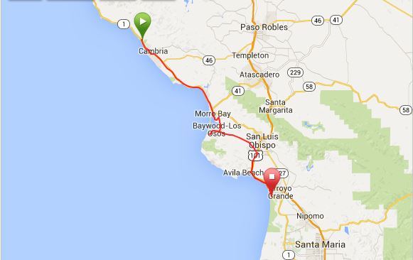
We were up early the next morning and off to Cambria for brekkie, as we were out of breakfast supplies. We stopped in at the Cambria Coffee Roasting Company for a coffee and some sweet treats. At 8am in the morning it was the busiest place on Cambria’s Main Street, which seemed to be a pretty good recommendation. The coffee was quite good and hit the spot. ![]()
From Cambria we got back onto Highway 1 and continued onto Morro Bay. Morro Bay is a lovely little spot. We detoured into town and then cycled past the Morro Bay Golf Club and along the bay. We had intended to cycle past San Luis Obispo, but we got lost and ended up in Baywood Los-Osos where we stopped for some Japanese for lunch – yum!
From there we should have cycled away from the coast along Los Osos Valley Road, however we went the wrong way and found ourselves cycling up the very steep Pecho Valley Road. It wasn’t a bad detour though, as we got an amazing view out over Morro Bay. After catching our breath we backtracked and followed Los Osos Valley Road in the right direction using Google Maps. We bypassed San Luis Obispo and eventually made our way to the coast. We passed glitzy Pismo Beach (we got yelled at here by a motorist for not stopping long enough at a stop sign), then Grover Beach until we came to sleepy Oceano.
Unfortunately, there were no hiker/biker campsites in the area. We caught up with the trail builder in Grover Beach. He was planning to stay at one of the RV Parks, but given that the private RV Parks charge upwards of $40 for a campsite, we decided to spend the night in a cheap motel in Oceano.
Our washing had never dried properly since Monterey, so I found a laundromat in Grover Beach to redo it. David had been itching to ride an ATV over the sand dunes since we passed Florence, Oregon and Oceano Dunes State Recreation Area seemed like the place to do it. So he went to organize a ride for the following morning, before meeting me in Grover Beach for yummy Thai Food – our first since Alaska!
KMs travelled: 93.62kms

Morro Bay, California

Morro Bay, California

David reaching the top of Pecho Valley Road, Los Osos

Views of Morro Bay from the top of Pecho Valley Road, Los Osos

Views of Morro Bay from the top of Pecho Valley Road, Los Osos
Thursday 13th November: Oceano to Gaviota State Park
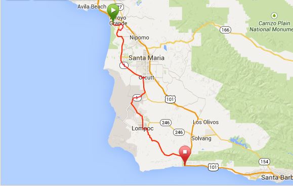
This was rather a dramatic day! It started when David couldn’t get one of his ear plugs out of his ear (Alpine Sleep Soft+). I tried to get it out with tweezers, but it was very slippery and I couldn’t grab it properly. We then tried pliers, but without success. By this point we were both starting to panic a bit (me more than David!) and I was envisaging that we were going to have to take him to the hospital to get it removed. Finally we got the sewing kit out and I bent a needle with the pliers, and holding the needle with the pliers I managed to hook the earplug with the needle and pull it out! Crisis averted. The earplugs went straight in the bin. Awful things!
Happily able to hear properly again, David went off for his date with the sand dunes. I am a slower cyclist than David, so I got a head start and cycled off towards Lompoc by myself. David often cycles on ahead, so I wasn’t worried about cycling by myself.
The road from Oceano to Lompoc was not particularly pretty and was rather industrial. Around Guadelupe the scenery became quite agricultural and the signs were nearly all in Spanish. It felt as though I had been transported to Mexico already, as the food choices in town consisted of tacos, tacos, burritos and tacos! It was a cute little place, with Spanish architecture too. It made me excited for what lies ahead across the border. ![]()
Around lunchtime I made a detour into the little town of Orcutt for a burger at Charlie’s Burgers. It was a great little burger shack, with good sized burgers and crinkle cut fries like my Mum used to make! Arriving by myself on my bike, I got a bit of attention at the burger shop. A lovely older couple invited me to sit with them and they kept me busy answering questions about our trip and when I would be meeting up with David again. Their concern was very sweet!
After lunch, it was back to Highway 1. There were two options for getting to Lompoc. Our friend Mateo had ridden both and described them as follows:
Going into Lompoc, you can go two ways. One is a long, fairly benign grade on a busy highway with good shoulders that takes you through Vandenberg Air Force Base. That’s pleasant enough. The other is a short, steep, curvy road called Harris Grade Road. Both are fine; I personally prefer Harris Grade Road, because it’s more rural and has less noise from traffic, but it doesn’t have much in the way of shoulders.
It was starting to rain, so I chose the long way via the Vandenberg Air Force Base. Unbeknownst to me, David chose the Harris Grade Road and overtook me to Lompoc.
By the time I got to Lompoc, I was feeling a bit peckish. I stopped in at Burger King for a burger to get me up and over the next major climb to our campsite for the evening, Gaviota State Park. I sent David a message on whatsapp to let him know I was about to set out from Lompoc. If David had been around, I probably would have called it a day, but as we still hadn’t met up, I had to keep going. A nice man in Burger King (but clearly not a cyclist), tried to warn me not to cycle on Highway 1 to Gaviota as the descent is too steep for bikes. But, as the Adventure Cycling Association maps directed us this way I just smiled, thanked him for his advice and kept on going.
We still had another 35kms to cycle to Gaviota and it was 4pm already by the time I left Lompoc. The climb has an elevation of 460m, but was very gentle. I kept wondering when the climb would start. Then, finally, I saw David. He got my message while in Lompoc and thought he must be behind me, but he was actually a little in front, as I had stopped to buy chicken for dinner. We continued the climb in the diminishing daylight. When we left Anchorage it was light until 9.30pm-10pm at night. We have lost 5 hours of daylight since then. By 5pm it is usually dark. We generally try to get to camp by 4pm, but that didn’t work out so well on this day. By the time we reached the top of the climb it was 5.30pm and pitch black. We put our fluoro vests on and turned on our helmet lights to make ourselves as visible as possible, but it was still a scary descent. Not because of the grade of the descent, but because of the traffic (including massive trucks) soaring past us at great speeds and due to the need to go slower to avoid any debris on the shoulder. By the time we saw the sign to Gaviota State Park our nerves were frazzled. So, you can imagine how we felt when we saw that the campground was closed! We kicked ourselves for not checking whether the campground would be open after our experience in Half Moon Bay. There were two caravans in the campground, so we went in to ask if we could camp there even though the campground was officially closed, as it seemed too dangerous to push on in the dark on the highway (the next campground was another 20kms away and there were no motels nearby). But, no-one responded to our calls, so we set up our tent, hopeful that a park ranger would take pity on us if they saw us. Thankfully, we didn’t receive any late night visits from park rangers! ![]()
KMs travelled: 113kms

David riding the dunes in Oceano Dunes State Recreation Area

David riding the dunes in Oceano Dunes State Recreation Area

David riding the dunes in Oceano Dunes State Recreation Area
Friday 14th November: Gaviota State Park to Ventura
We ate breakfast watching the sunrise over the ocean, with a number of cruise ships glittering on the horizon. It was a beautiful sight and made us want to get up at this time every day to enjoy more sunrises and to maximize our riding time.
We passed El Capitan State Beach Campground and were super glad that we didn’t attempt it the previous night, as to get to it, we had to ride across a narrow bridge with no shoulder and lots of traffic. We would not have felt comfortable riding that in the dark. We hardly felt comfortable riding it in daylight! ![]()
Just before Santa Barbara we left the highway and followed some local bike paths through Santa Barbara University. It was just before 9am and the bike paths through the campus were absolute madness. It was fantastic to see so many students riding bikes, but I felt safer on the highway! ![]()
After leaving the university we cycled along the coast for a short way and then followed Google Maps’ directions to downtown Santa Barbara via a riverside bike path and a number of back streets. We met a friendly local cyclist along the way, who had also done some cycle touring, who helped us with directions.
When we finally made it to downtown Santa Barbara we were in serious need of “second breakfast”! We went to “Sambo’s on the Beach”, which seemed to be a bit of a Santa Barbara institution. We had yummy omelets and a much needed coffee.
Santa Barbara is a beautiful place, with a holiday feel to it. Sipping my coffee at Sambo’s, I felt as though we had finally reached the “California” that is portrayed in the movies and on TV. The girls wore lots of lip gloss, had shorter skirts and killer tans. We watched as girls glided past on roller blades and waitresses served “egg white omelets”, fruit salad and champagne to the people around us. It was markedly different, and much more health conscious than the small town America that we had become accustomed to (San Francisco being the notable exception). People were very friendly and kept asking us where we had started from. I wish we could have stayed longer, but we needed to be in LA by the 15th.
Leaving Santa Barbara, we pedaled along the coast past Carpinteria and eventually onto Emma Wood State Park where we watched some surfers in action. Emma Wood State Park campground only caters to RVs, so we decided to treat ourselves to a cheap motel in Ventura, rather than stay in our tent in a private campground.
We bought some beers at the local supermarket and enjoyed the luxury and comfort of a shower and bed!
KMs travelled: 104kms

Our brekkie spot in Santa Barbara!

Santa Barbara

Santa Barbara

Santa Barbara

David soaking up some rays in Santa Barbara

Hello Santa Barbara!

Downtown Santa Barbara

The jetty, Santa Barbara

Palm trees, Santa Barbara

Downtown Santa Barbara

On our way to Ventura, California

On our way to Ventura, California

On our way to Ventura, California

We stopped to watch some surfers on our way to Ventura, California

We stopped to watch some surfers on our way to Ventura, California

We stopped to watch some surfers on our way to Ventura, California
Sat 15th November: Ventura to Los Angeles
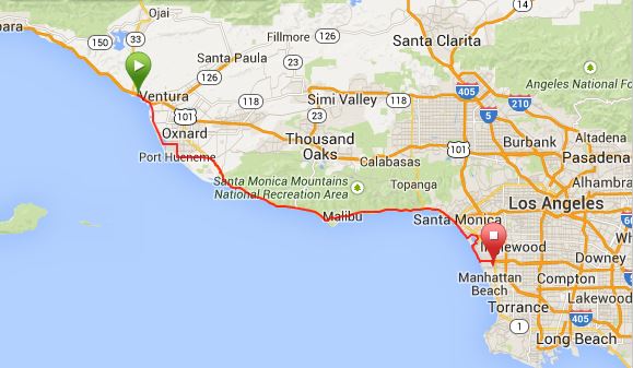
We planned to stay with my brother’s girlfriend’s (Michelle) parents while in LA (thanks Elsie and Henry!) and we had indicated that we would be at their place between 3-5pm, so we got up early to make sure that we could keep our promise. We had been advised by a local cyclist that there was nothing to see but an urban jungle between Ventura and LA and that we would be better off catching the train, but again, we were glad we didn’t take the advice as it was a great ride.
Being a Saturday morning, the local road cyclists were out in force. They were very friendly and chatted with us as they went past. We past a beautiful harbor full of boats and a cool outdoor aircraft museum that David was drooling over. We stopped at Point Mugu for “second breakfast” and then made our way towards the beautiful Malibu coast. There was a lot of traffic and some steep hills around Malibu, but we received a lot of support from the locals. We had a “coke stop” at a petrol station in Malibu and were swamped by people wanting to know where we had come from and where we were going to. Cars honked their horns as we trudged up the hills and I will never forget one guy who stood at the top of one big hill and high fived me when I got to the top and called me a “champion”! The attention was kind of overwhelming, it had been a bit like this since Santa Barbara, but at the same time, it was really awesome!
Malibu was very cool and is essentially one never-ending beach! It was full of surfers and had a relaxed holiday feel to it.
As we got nearer to LA, the traffic increased and it became a bit dicier on the road. Nevertheless, the cars were courteous, and I didn’t feel unsafe. When we got near to Santa Monica, we pulled off the road for a breather. A local cyclist approached us and told us that we should cycle on the Beach Bike Path from that point to El Segundo, as the main highway gets too congested for bikes. We were grateful for his advice and enjoyed riding on the beach bike path for the most part, although at times it became so crowded with rental bikes, roller bladers and pedestrians that we wondered if we wouldn’t have been better off on the highway. Nevertheless, it is a fabulous bike path, which runs right through the centre of the beach. Very LA. Very cool.
Thanks to Google Maps we made it to Henry and Elsie’s place in El Segundo by 4pm. They had planned an amazing 4 course dinner party with friends (including Michelle’s best friends, Daniel and Noel) for our arrival, which was a fabulous end to this section of our journey.
KMs travelled: 114kms

Gorgeous harbour views on our way to LA

Gorgeous harbour views on our way to LA

On our way to LA

Outdoor aircraft museum near Ventura County Naval Base, California


Outdoor aircraft museum near Ventura County Naval Base, California

Outdoor aircraft museum near Ventura County Naval Base, California

David having second breakfast on our way to Malibu

Point Dume State Beach

One of the many beautiful Malibu beaches

Malibu baby!

Gorgeous coastline, Malibu

Gorgeous coastline, Malibu

Gorgeous coastline, Malibu

Surfers at Malibu

More beautiful Malibu beaches

We made it to LA!!

The fabulous bike path through the beach in LA

Views from the bike path, LA

Views from the bike path, LA

The fabulous bike path through the beach in LA

The fabulous bike path through the beach in LA


Recent Comments